


With the following descriptions you can plan your tour individually and theoretically also carry it out without more detailed information on the individual stages, as the signposting is very good.
GPS data is available as .kml files for each stage. They were recorded by myself while hiking and subsequently corrected for the "rest kilometers".
Use this free service and download the planned tours - you will feel safer in some places!
You can convert KML.files to GPX.files here
The complete tour as a GPX-file is available from outdooractive or as direct download here:
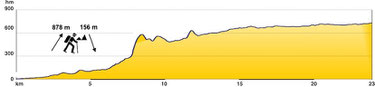
1st stage 23 km (14 mi)
approx. 6 hours
Diakopto - Kalavryta
Almost the entire route leads over railroad tracks through a breathtaking gorge. From the Kato Zachlorou middle station (about half way) it is worth visiting the Mega Spileo monastery. Allow 2-3 hours in addition to the normal hiking time.

2nd stage 18 km (11 mi)
approx. 5 ½ hours
Kalavryta - Planitero
Leave the town via meadows up to the main road towards the ski resort. Once you reach the road, continue for approx. 2.5 km (1.5 mi) and then over field paths and meadows to above Ano
Lousi. From here, follow a dirt track to a stable and from there via goat tracks and dirt tracks to a river ford.
(There is a possible detour to the “cave lakes” which are worth a visit - allow approx. 2 hours more).
From the river ford, take the goat paths up to a dirt track and follow this to Planitero. A very cozy place is located at the springs of the Aroanios river.


3rd stage 16.5 km (10 mi)
approx. 7 hours
Planitero - Likouria
From the ´Piges restaurant´ at the spring, the stage begins in the plane tree forest and leads over a steep section of forest on a path to Armpounas. From there, a beautiful traverse on a stony path to Agios Nikolaos. From here, take a dirt track to just before Tourlada and a steep and stony path to a saddle above Krinofita. From the saddle, descend either via meadows and paths or a gravel road to Krinofita. Continue through the village to the highest point - the chapel of Agios Athanassiou. From here, take a stony path up to a saddle and from here take another rocky path down to Likouria.


4th stage 12 km (7.1 mi)
approx. 4 ½ hours
Likouria - Dara
You reach the source of the Ladonas River via a beautiful mule track and approx. 2 km (1 mi) of asphalt road. From here you will hike via goat paths and an exposed mule track up to Pagrati. The route continues on concrete roads through the village, then on a track between trees and further on goat paths until you reach a dirt track that leads you down to Dara for the last kilometer.


5th stage 18.5 km (11.5 mi)
approx. 5 hours
Dara - Vytina
A nice walk without effort and exclusively on asphalt and unpaved roads.
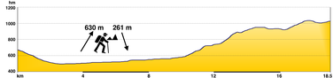

6th stage: 17 km (10.6 mi) approx. 6 hours.
on the new route
Vytina - Menalon refuge - Kardaras
The new route was completed, cleaned and marked by the Tripoli Hiking Association in June 2012!
The new route has been included in the Anavasi maps since 2014. The old route via the asphalt road can still be followed; however, all markings along the asphalt road have been removed.
In contrast to the old route, the new route - finally! - is also a regional hiking trail with regional signage (yellow square on a white background).
After approx. 2½-3 hours (10 km/ 6.2 mi) of walking from Vytina on the regional hiking trail with a yellow square on a white background (also the new E4), you will come to a fork with another
regional hiking trail with an orange square on a white background. This regional hiking trail (leading from Vlacherna via Kardaras and Roïno to Piana) also becomes the new E4 from here to
Kardaras.


7th stage 20 km (12.4 mi)
approx. 5 ½ hours
Kardaras - Tripoli
To get from Kardaras to Kapsia, follow the orange markings for another 2.5 km (1.6 mi). The path runs close to the asphalt road. Where you meet a smaller asphalt road that joins the main road
about 20m (0.1 mi) further on, the local orange hiking trail (leading to Roïno) and the E4, which leads along a dirt road and the last 2 km (1.2 mi) on asphalt road to Kapsia, separate.
From here it is an easy hike - almost a walk - over goat tracks and tracks through beautiful flower meadows to Perthori and from there over gravel and asphalt roads back to civilization in
the center of Tripoli.


8th stage 20 km (12.4 mi)
approx. 6 hrs.
Tripoli (by cab to Psili Vrisi) - Agios Petros
From Psili Vrisi continue on a dirt track to the ´Panagia´ chapel, from there through the stream bed to just below Ano Doliana, then climb a steep section through the forest to the village
(if the water level in the stream is too high from the ´Panagia´ chapel, all on the main road). From the center of the village continue via a concrete road and footpaths to above the village
and from there via paths and dirt tracks to the road that leads from Vourvoura to Agios Petros.
There is a shorter option to get to the village from here (and you don't need to return to the village twice, as this is also the start of the next stage):
Do not follow the E4 markers up to the right, but stay on the asphalt road until it joins the main road shortly after a building materials and timber magazine. Turn right there.
You can shorten the 4 km (2.5 mi) long loop that the road describes and skip it in the following way: After approx. 200M (0.1 mi), at a vineyard slope fenced with barbed wire, follow the
steeply sloping concrete path to the left away from the road down to some sheep pens. From here, follow a footpath that takes you down a steep descent to the bottom of the gorge. On the other
side of the gorge, walk up the concrete path and past the cemetery to the center of Agios Petros.


9th stage 21 km (13 mi)
approx. 5 ½ hours
Agios Petros - Vresthena
Easy hike, mainly on forest paths at the foot of the Parnon Mountains.
In Vresthena there is a kafenion and tavernas, small shops and a communal hostel, which is currently closed. The former operator, Jorgos Primba (lives in Sparta, Phone
6980452973), rents out his private house. If required, contact him at least two days in advance to hand over the keys. On arrival in the village, next to the large church, there is the
Taverna to Kamari. The owner (Panajotis Grigoris) and his wife speak English and are very helpful.


10 March 2020 until further notice
Please note:
Between Vresthena and the bridge at the end of the river valley (approx. 9 km long) there is a goat herder with 7 dogs. The shepherd is often absent and the dogs guard the herd alone and can be dangerous. Unfortunately, the shepherd is not (yet) willing to co-operate.
We therefore strongly recommend that you either take the road towards Sparta (about same distance) until the bridge. Or take a taxi from Sparta and skip the whole route. (Taxi operator Mr Roïnos (Tel 6937134229) is informed and will pick you up at a special price)
Panajotis Grigoris, the owner of the tavern 'to Kamari' next to the church, is helping in this matter as much as he can and we hope for a better solution soon!
Until then, we're just sorry ...
10th stage 18.5 km (11.5 mi) approx. 5 ½ hours (Theologos - Sparta by cab)
Vresthena - Theologos
A great river valley hike below Vresthenas to the main road Selassia-Vresthena/Vasaras and from there on dirt tracks and asphalt road through olive groves to the chapel ´Agios Georgios´ and further on dirt tracks and the last 1,5 km (0.9 mi) on asphalt road to Theologos. From there it is best to request a cab from Sparta as there is no overnight accommodation available in Theologos and the route to Sparta (9 km/ 5.6 mi) leads along the asphalt road only.


11th stage 15 km (9.3 mi) (from Sparta)
approx. 4 ½ hours
Sparta - Anavryti
From the central square in Mystras, take the road towards Parori, Ag. Ioannis. At the first corner, still in the village square at Mystras-Inn, turn right (E4 sign) and follow the marked road for approx. 3.5 km (2.2 mi) until you reach a crossroad. The road on the right leads to Taygeti. However, you continue uphill and after approx. 1 hour you reach a gorge where the small chapel ´Metamorfosis Sotiras´ is located under huge plane trees. Next to the chapel is a spring with cool water. The E4 route from Mystras to here leads along forest paths.
To get here, there is a more beautiful option from Mystras, but it is not the E4. This route leads through a gorge in which a water pipe was laid in a sometimes adventurous
way:
From the central square in Mystras, walk about 1 km (0.6 mi) on the asphalt road to Parori.You will pass a restaurant on the right-hand side with a small waterfall at the far end of the
terrace. Just after the bridge, look out for a hiking sign (red triangle) on the right pointing uphill to the right. From here you can't go wrong and after about 45 minutes you will reach the
place described above, at the ´Metamorfosis Sotiras´ chapel.
From the chapel, the path is easy to find - it leads along a forest road to the Faneromeni monastery and the last stretch along a path to Anavryti.


The Byzantine site of Mystras is well worth a visit. It is one of the most beautiful and best-preserved sites in the Peloponnese. You should allow around 3 hours for a visit, including the hike there and back from Mystras.
My suggestion is to take a taxi directly from Sparta or Mystras to the entrance, visit the site and start the stage from the site.
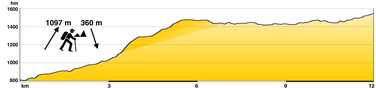
12th stage 12 km (7.5 mi)
approx. 4 ¾ hours
Anavryti - Taygetos refuge
A real mountain hike to the foot of the highest peak in the Peloponnese.This section is very well marked and is often undertaken by groups from the Sparta mountaineering club.
The Taygetos refuge is located at 1,550 meters (5085 ft) above sea level and has mattresses and blankets for 20 people, a heating stove, gas kitchen and outside toilet.
Note: Unfortunately the refuge will only be open for the night from Saturday to Sunday from fall 2024. Except for larger groups and then mostly only for members of the Sparta
hiking club or by appointment.
If you wish to spend the night here, you must contact the Sparta Mountaineering Club: (www.eosspartis.gr), Tel: 27310/22574).
Or contact the hut warden, Panajotis Pappas, cell phone 6945832701, at least one week in advance.
Camping on the hut grounds is permitted at all times, but fires are absolutely forbidden!
A good alternative is described next door.


E4 sponsor accomodation
“Kaliva Sophia & Kostas”
Sophia and Kostas from Xirokampi rent out their well-equipped hut via AirB'n'B. With sleeping facilities for up to 10 people. With kitchen, shower, toilet and wood stove.
Sophia cooks simple meals on request and brings them to the hut.
For direct contact (she speaks some English): Phone 6978017240

13th stage 16 km (9.9 mi)
approx. 5 ½ hours
Taygetos refuge - Arna
The mountain hike continues ... well marked. This is probably the most strenuous stage. You need to be in good physical condition, but if you have already hiked this far, you will be fit
enough.
From the chapel of Agios Georgios, this (shorter) variant applies due to storm damage:
Follow the forest road past the chapel, descending to the left (opposite the E4 markings). After 700-800 m (0.4-0.5 mi), at the first crossroad in the forest continue straight ahead (not to
the right). After approx. 3 km (1.9 mi) from the chapel, the forest road makes a 180° turn to the right as it descends. In the middle of this bend, turn left onto a path marked E4, away from
the forest road, ascending into the forest. (Caution: Do not miss this turn-off, GPS 36°54`09``N - 22°21`38``E, otherwise you will follow the E4 markings in the opposite direction). From
here, take a path uphill for a few hundred meters through the forest and then on a rocky, somewhat strenuous path, over the Kamenos Vrachos, down to Spartia and the last km/ mi on asphalt to
Arna.


14th stage 16 km (9.9 mi)
approx. 5 hours
Arna - Agios Nikolaos
From Arna down to a stream and then along a seemingly mythical path to the monastery of 'Panagia Jatrissa'.
In front of the monastery, the path leads along the sloping asphalt road towards Gythion. Go past the first dirt road that turns to the left and look out for an E4 sign to the left of
the road on a conifer about 1 km (0.6 mi) from the monastery. The path leads down to the left of the road into the next village of Kastania. From here, follow the road and small side roads to
Agios Nikolaos.
In addition to the E4 sponsor accommodation, there is a second place to stay in Agios Nikolaos, but this is only open on request: Mr. Nikolaos Chilakos, (landline: 27330.22054, mobile
6974321315)


15th stage 30 km (18.6 mi) approx. 7 hours (25 km/ 15.5 mi without the Desfina loop)
Agios Nikolaos - Gythion
There is a new route. However, it has not yet been registered with the relevant authorities as the official new route of the E4 and is therefore not yet signposted.
Nevertheless, the existing (old) route has been signposted along its entire length to Gythion, because nobody knows when the new route will get the go-ahead. The current route runs along
asphalt and unpaved roads and is easy to find following the E4 markings. The loop from Desfina can be shortened - there are two markings to help.

